

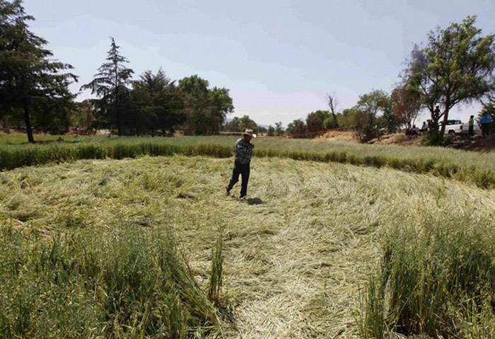
Mandala Formation in Tlapanaloya, Mexico
Five Crop Circles: Mexican Wave & Water Wakeup Call
Siderealview's Blog
March 20, 2011
In the last few years the eyes of the world have been fixed on Crop Circles in the (Northern hemisphere) summer months. The eyes of the world are elsewhere at the moment. So it is not surprising that five crop circles which appeared over last weekend's Vernal Equinox in two oat fields in Tlapanaloya, 33 miles north of Mexico City were given little media attention. Reuters, the Washington Post and Mexico's El Universal seemed to be the only news media interested in the phenomenon. They are the first new appearances since the January surprise in Java.
'Tlapanaloya' is the old name for this fertile farming region, still tilled and irrigated along indigenous/traditional lines and miraculously spared in Mexico's headlong drive for industrial 'revolution'. In its new guise as Tepeji del Rio de Ocampo, Hidalgo, Mexico, it is surrounded by industrial development: several hydro dams, effluent canals, a bauxite-cement works at Cruz Azul, a large military installation, several multi-lane highways (autopista), a national rail line and access roads to feed nationally-supported mineral extraction and mining operations to north and west.
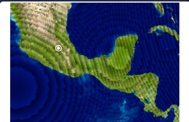
Tlapanaloya lies at latitude 19°52' N longitude 99°21' W. Latitude 19° is significant as the Parallel along which the southern boundary of the North American tectonic plate meets with the Central American plate. Here a line of volcanoes rising to 16,000 feet -the Cordillera de Mexico (or Neovolcanic Ridge)- stretches from the Revillagigedo Islands in the Pacific Ocean to the Gulf of Mexico. Seismic activity is frequent here, and the valley is considered an earthquake-prone zone.
Located thirty-three miles north of central Mexico City, Tlapanaloya lies within the closed basin of the ancient Valley of Mexico. At around 7,000 feet, it was the original picturesque Lake District of five lakes, and domain of the people of Teotihuacan, the Toltec and Aztec. The Toltec and Aztec spoke Nahuatl.
The Nahuatl name for the Valley of Mexico was the Anahuac, meaning the plateau or 'place between the waters'. Now those waters are crying out for help.
There were originally five great lakes in this stunningly beautiful setting, hemmed in on all sides by mountain peaks that rise to 16,000 feet. But in the last 200 years successive dams and reservoir construction schemes have funneled and tunneled the waters away from their traditional lakebeds and aquifers. Their clear streams were instead diverted to become waste carriers: 'effluent'-glorified drains for the population of megalopolis Mexico City -now bursting at the seams with a central population in excess of nine million souls (2010 census 8,851,080...).
Mexico City's ancient name was Mexico-Tenochtitlan after the Nahua-Aztec tribe, Mexica: it means the 'co-' place of the Mexica among stone cactuses'. In symbolic terms, the image (represented in Mexico's coat-of-arms and flag) is one of an eagle perched on a cactus which grew from a stone (supreme achievement through the greatest of adversity in environment).
The Rio Tula -the Tula River, from which the nearby industrial town of Tula Allende takes its name -is, according to Mexico's National Water Commission [Comisión Nacional del Agua de México], one of the most polluted rivers in the country. Tula (Tollan) was the Toltec capital, Tollan-Xicocotitlan in its heyday -8th-10th centuries AD (Post-Classic period) -but suffered brutally under Spanish invasions of 16thC, when its society collapsed.
The Toltec called their capital Tollan, surrounded by natural wetlands -a fertile gift from their Sun-and-star god Quetzalcoatl-Xicocotitlan, the 'place among the reeds near the home of the wasp/bee'.
The Atlanteans of Tula Grande, basalt figures over 12 feet high carved from volcanic rock guard the Toltec Tollan temple to Quetzalcoatl (10th-12th century AD).
The great Atlantean statues which guarded the temple of serpent-god/Venus-morning-star-Queztalcoatl, prior to Tollan's destruction by the Spanish, have been reinstated to stand on their original plinths, rescued from the ignominious ditch where they were found buried -hidden by retreating Toltec from Spanish gaze...
Tlapanaloya Crop Circles in Chinampa 'Gardens'
Fortuitously, all five of last weekend's crop circles appeared in oat meadows still farmed in the Chinampa style-planted and lovingly tended in traditional small rectangular-shaped fields by local Tlapanaloya farmer Enrique Hernandez. He was reported to be mystified by their choice of location but delighted that his crop was not spoiled. On the other hand, if he had been assured that his own way of life and his organically-grown porridge oats -now with their hugely enhanced CC/ET-vibration- were teetering on the edge of extinction, he might feel proud.
It is becoming clear that-whatever one feels about the provenance of crop circles the world over -they do occur in locations which require our attention.
Given that the Tlapanaloya crop circles did NOT contain elaborate interior designs -as are now commonplace in sophisticated annual formations on Salisbury Plain and the fields of Wiltshire's electromagnetic aquifer -it seems a simple intuitive leap from the five Mexican crop circles to a crisis water situation, symbolized by the five extinct Great Lakes of the Basin of Mexico-along with their important historical contribution to this crucial aquifer.
They also occur as part of a triangle of 33: Their point is 33 miles north of Mexico City. Also 33 miles northeast of the city lies Teotihuacan, where equinox is seriously celebrated each year. And Teotihuacan lies approximately 33 miles east of Tlapanaloya.
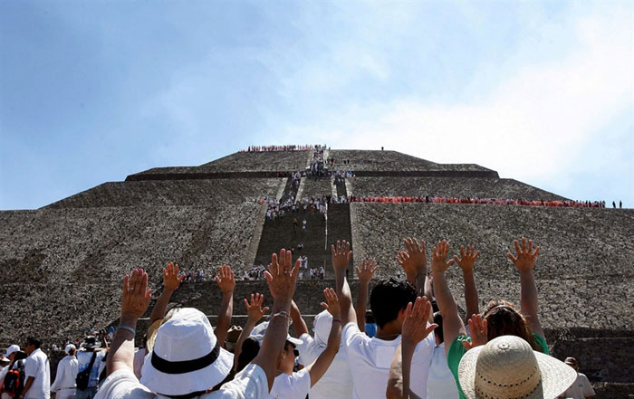
Equinox sunset over the Pyramid of the Sun at Teotihuacan, Valley of Mexico, March 20, 2011
The crop circles appeared on Equinox weekend when hundreds of thousands of Mexico City residents head for the pyramid of the Sun at Teotihuacan-to pay their respects to the setting sun as it disappears behind the pyramid. Teotihuacan, Toltec's 'place where men become gods' lies just 33 miles east of Enrique's field. Its central avenue's due N-S alignment, on which the pyramid's shadow casts a precise shadow at the moment of dusk, remains today a fascination for Mexicans who traditionally celebrate the onset of spring on Equinox. This year was no exception. Teotihuacan was mobbed.
It was also the weekend before the worldwide celebration of World Water Day, March 22nd.
Water is becoming scarce in many countries with over-population and rising mean annual temperatures. Water will soon be a commodity more precious than the metals mined in the Mexican hinterland.
The present explosion of shanty towns which have sprung up in the last decade around the Mexican megacity have bolstered the population of MCMA (see above) to 21 milion people. While canals and drainage systems channel their human waste North into the Valley of Mexico agricultural region centered on (the crop circles of) Tlapanaloya, a clean drinkable water supply continues to be a problem in the city.
Industrial growth within an enclosed basin has not only produced pollutants in smog, but water quality issues for the Valley. Over-extraction of ground water has caused new flooding problems for the city as it sinks below the historic lake floor. Seasonal flooding was thought to have been historically 'cured' by the Spanish and successive Mexican governments by the very act of drainage. Now excessive drainage-and extraction of more water than is being replenished naturally causes subsidence and the need for further infrastructure -more pipes and tunnels.
For a high mesa totally enclosed within mountain ranges, the Valley is completely dependent on its groundwater supply. This has traditionally come from the underlying aquifers, the upwelling of seasonal springs supplemented by (previously unwanted) flooding and rains. These underground springs and wells are now almost exclusively the source of drinking water for the greater metropolitan area of Mexico City. With the rapid addition of shanty towns around the city's outer limits, more water is being pumped out of the city's underground reservoirs than Nature is pouring in -[main aquifer currently pumps 880,000 USgallons/minute while the water table refreshes at around 440,000 gals/min] -that is, water is replenishing at around half the extraction rate.
Much of the city has now sunk below the ancient lakebed level and it continues to sink at around 15 inches per year. Water from the surrounding mountains which always flowed towards the city, now passes through shanty towns where there are no city 'services' (water supply or sewage removal), so the rivers become sewers -which contribute to an ongoing health risk in the capital. MCMA is struggling to prevent this contaminated water from entering the drinking supply.
The present dilemma is specific to Mexico. But clean and clear water is a blessing and a gift we may not have appreciated enough until now. All this communicated by a chance appearance in two traditionally-planted-and-irrigated Chinampa fields in a rural district of central Mexico? you ask?
Perhaps not explicitly, but we have had a little experience of messages transmitted in the last decade of crop circles in other areas of the world where aquifers-and their underlying electromagnetic mysteries -have contributed enormously to the medium.
This Mexican Wave may indeed be sending us a High Five: a reminder to reconnect with our traditional lifestyles. But it is more likely to be a distress signal -a wakeup call. We would be well-advised to listen and heed its message.
Analysis
As detailed in the article above, this five-circle mandala formation in central Mexico is carefully reminding us all to become aware of the presence of sacred waters springing from below the Earth, as recently rediscovered at the nearby site of Tlacote, Mexico, and further south in La Maná, Ecuador and in Iyacyecuj Cave, Peru.
The date and location of this new crop formation in Tlapanaloya, Mexico are also significant - marking the day of the equinox and being located close to the ancient Toltec pyramid site of Teotihuacan, where admiring visitors gather to witness the sunrise every equinox, and every solstice. The mandala design of the formation references the circular force of sound that comprises the Earth's nonlinear field of ultra-low frequency resonance, which is the fundamental cosmic force uniting the collective function of all of the ancient pyramids and megalithic temples of the world.
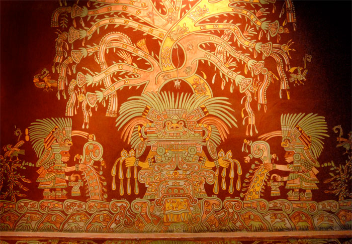
The base length of the Pyramid of the Sun at Teotihuacan closely matches the 760-foot base length of the Great Pyramid of Giza, Egypt, as both pyramids are designed to resonate at the 1.45 Hz wavelength of the human heartbeat, thereby synchronizing the biorythms of all initiates at both pyramid sites on opposing sides of the globe. The monumental Toltec pyramid site of Teotihuacan is named as the 'place-where-man-becomes-god', for the rejuvenative effects of the 1.45 Hz heartbeat resonance present within in pyramid's chambers, and the immortality granted by the healing properties of the glowing HHO plasma plumes that will be generated around and within the ancient structures by the galactic superwave of December 22, 2012. The HHO plasma plumes of the 'Red Dawn' are exactly depicted in this mural on the interior walls of Teotihuacan itself (below):
Tlapanaloya, Mexico (19.93°N 99.10°W) is 7,669 miles from Giza; a distance that comprises 30.8% of the Earth's mean circumference (of 24,892 miles). Giza lies along the 30th latitude, while Tlapanaloya sits near the 20th latitude. Other similar mandala formations have apeared along this 30% resonant circle distance include Calfornia's crop circles which have appeared in Solano County, in 2003 and 2004, in Red Bluff in 2007 and in Hidden Valley and Greenfield in 2010.
The plasma orbs that form these astounding mandala formations in crops worldwide are weaving the transcendent mathematics of consciousness into the fields of our farmers, reawakening our collective awareness of sacred convergence points of infrasound standing waves in England, Netherlands, Germany, Italy, Russia, Indonesia, and in the US in Illinois, Michigan, Ohio, Tennessee and Louisiana.