
Infrasound Pulsations Generate Quakes and Tornadoes in the Midwest US
Survey of Tornado Tracks Reveals ULF Weather Manipulation by Nexrad Towers
by Alex Putney for Human-Resonance.org
July 4, 2012
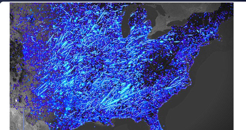
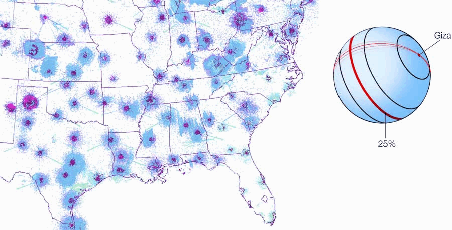
A comprehensive survey map of the pathways of severe storms and tornadoes across the continental US recently released by John Nelson of IDV Solutions has inadvertantly provided crucial evidence of US government weather manipulation. The brightness of the tracks corresponds to the most intense tornado activity, using the standard F-scale.
Nelson mapped 61 years of severe weather datasets provided by the NOAA, stating 'I just connected those lines to get a general path the tornado took. When you view it at the national scale, right away you've got these kind of claw marks.
He had noticed the unusual clustering and overwhelming directionality of the events: 'Right away, I got a sense of hotspots, and areas that were unexpectedly devoid of tornadoes.' A clear correlation between the straight line paths of the most severe tornadoes and the locations of Nexrad towers is quite obvious, as displayed below.
Scroll down to my previous article on the subject from May 23, 2011 concerning the deadly Joplin, Missouri tornado event. The article presents a complete explanation of the methods of weather manipulation by Ultra Low Frequency (ULF) technologies stolen from Nikola Tesla before he was assassinated. This groundbreaking article also includes an animated map of the network of Nexrad tower facilities and their nonlinear grid distribution in parallel rows in alignment with the Great Pyramid of Giza, Egypt.
Scientists Detect Seismic Signals from Tornado
Terra Daily
March 16, 2012
An Indiana University geophysical experiment detected unusual seismic signals associated with tornadoes that struck regions across the Midwest last week - information that may have value for meteorologists studying the atmospheric activity that precedes tornado disasters.
The experiment by IU researchers involves deployment of more than 100 state-of-the-art digital seismographs in a broad swath of the U.S. midcontinent. One of the twisters that struck southeastern Missouri and southern Illinois on Feb. 29 passed through the seismic detection array.
"In examining the seismograms, we recorded unusual seismic signals on three of our stations in southern Illinois," said Michael Hamburger, professor in the department of geological sciences at IU Bloomington and one of the researchers conducting the experiment.
"The seismograms show a strong, low-frequency pulse beginning around 4:45 a.m. on Feb. 29. Our preliminary interpretation, based on other seismic records of tornadoes, suggests that we were recording not the tornado itself, but a large atmospheric pressure transient related to the large thunderstorms that spawned the tornadoes."
The seismographs that detected the pulse are near Harrisburg, Ill., a town of 9,000 where a pre-dawn twister caused extensive damage, killed six people and injured about 100 more.
IU researchers initially feared that some of the instruments might be damaged by the storm, setting back a National Science Foundation-funded project that included the investment of hundreds of thousands of dollars and months of effort.
But when principal investigator Gary Pavlis, an IU professor of geological sciences, checked the digital recordings of the Illinois stations on Feb. 29, he found they were still alive and streaming data. As he checked further, he discovered the strange "tornado seismograms" that were recorded on seismographs near Harrisburg.
Hamburger said a seismic pressure gradient associated with the tornado produced a slow, minute tilting of the seismograph that lasted for several minutes. He said this sort of pressure-related signal may help scientists better understand atmospheric activity that takes place right before tornadoes touch down.
The IU researchers are working with colleagues at the University of California San Diego to try to compare recordings with other tornado-related signals and to dig deeper into the analysis.
While seismographs have been known to detect seismic activity related to tornadoes, it is highly unusual to have state-of-the-art digital instruments recording information in such close proximity to a tornado, the researchers say.
The IU seismic experiment, dubbed "OIINK" for its geographic coverage in parts of the Ozarks, Illinois, Indiana and Kentucky, includes the positioning of 120 seismometers to study earthquakes and geological structure in a key area of North America. Installation of the instruments began last summer. They are recording thousands of earthquakes from the study area and around the world, as well as nearby mining and quarry explosions.
The $1.3 million, four-year undertaking is part of the NSF's EarthScope program, which seeks to cover the entire U.S. with a grid of detection devices for the purpose of better understanding seismic activity and predicting earthquakes. Researchers liken EarthScope to "an upside-down telescope" that allows them to look into the Earth and gain a better understanding of seismic forces.
US: Wanna Experience the Apocalypse Before it Happens? Visit Oklahoma!
by Steve Olafson for Reuters
November 12, 2011
After one of the strangest local weather days in memory, an Oklahoma woman with a sense of humor asked on Twitter earlier this week: "Wanna experience the apocalypse before it happens? Visit Oklahoma!"
She posted that on Monday night shortly after a 4.7-magnitude aftershock earthquake shook the state. The temblor occurred not long after six tornadoes ripped through southwest Oklahoma, which was preceded by flash-flooding in an area that's been plagued by a historic drought.
"Seriously, WHAT'S GOING ON?" someone else tweeted that night.
The answers vary. Global warning? Coincidence? Bad luck? Bad timing? End of time?
There's agreement on only one thing: It's been weird all year.
"Even for Oklahoma, this is crazy," said Rick Smith, a National Weather Service meteorologist in Norman. "Since January, we've been setting records. People are just kind of amazed and shocked."
State records set this year have ranged from the lowest temperature (31 degrees below zero in Nowata in northeast Oklahoma) to snowfall in a 24-hour period (27 inches, also in Nowata) to the largest hail stone (a spiky, six-inch piece recovered in Gotebo, in southwest Oklahoma).
This year also produced the state's highest-ever-recorded surface wind speed (151 miles per hour near El Reno, outside of Oklahoma City) and biggest known earthquake (5.6 magnitude, breaking the 1956 record).
On Wednesday, Governor Mary Fallin declared a state of emergency for 20 counties because of earthquakes, tornadoes and severe storms...
Weather Modification by Nexrad Stations Generates Severe Tornadoes, Killing 116 in Joplin, Missouri
by Alex Putney for Human-Resonance.org
May 23, 2011
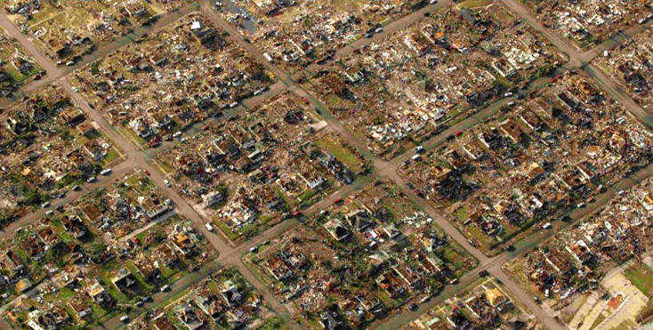
This latest spate of deadly tornado activity in the central United States has claimed the lives of 116 people in Joplin, Missouri. The town was cut in half by a 1.5 mile-wide swathe of destruction, with all homes and trees torn to the ground (above).
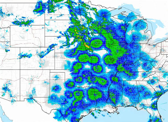
The devastating strings of tornadoes that have ripped through the midwest US for the last 3 weeks have formed a repeating pattern of destruction. Several unusual geometric patterns have been observed on Doppler radar throughout this time period that correspond to the locations of National Weather Service meteorological stations named Next Generation Radar, or 'Nexrad'.
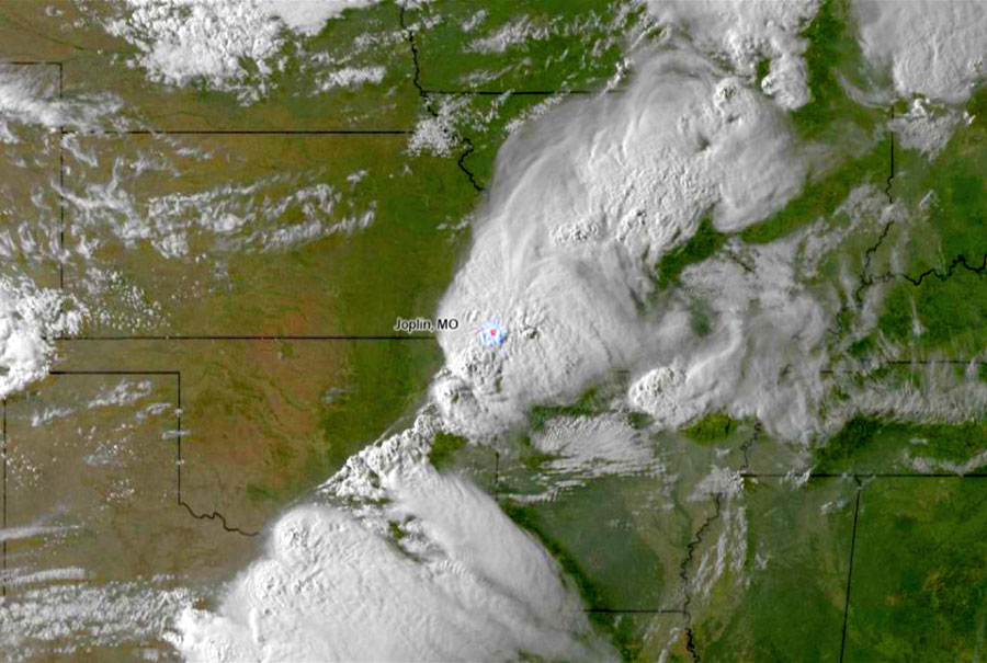
Are these called 'next generation' radar stations for their secret capability for ultra-low frequency weather manipulation by increasing atmospheric ionization? Global patterns in precipitation rates have been closely correlated with solar activity, as transmitted through infrasound resonance in fluctuating waves of intensity. Cloudcover observations during the linear formation of the thunderstorm cells shows the alignment of Joplin, Missouri on the path of devastation (below). The major vortical activity distributed along this precise alignment directly corresponds to the locations of Nexrad installations:
Tornado 'alleys' have been long recognized as danger-zones throughout the midwest US as strings of tornado cells are often observed to move along specific alignments where certain conditions most commonly occur. A linear alignment of counter-rotating tornado cells extends diagonally through the states of Texas, Oklahoma, Missouri, Illinois and Indiana and passing through the large cities of Tulsa and St. Louis.
This alignment of storm centers are located directly over Nexrad installations, themselves constructed by US government contractors for the National Weather Service (throughout the 1980s and 90s) along a straight line that extends around the planet directly through the gravitic center of Earth - the Great Pyramid of Giza, Egypt (overlaid in red, below). The 25% circumference distance from the Giza pyramids passes through Savannah, Georgia, Madisonville, Tennessee, Indianapolis, Indiana.
In fact, the entire network of Nexrad radar stations have been constructed within a nonlinear grid system that corresponds to the convergence points of infrasound standing waves transduced by the pyramids, earthen mounds and megalithic temple sites throughout the world. The array of focal points of ultra-low frequency resonance is stimulated by inaudible emissions from the many Nexrad radar stations for the artificial generation of severe weather and massive tornado cells.
Just as the Sea-Based X-Band radar has been weaponized to secretly induce mega-quakes and disastrous tsunamis as witnessed in Japan, the Nexrad radar installations have been weaponized to agressively drive the atmosphere into vortical patterns known to generate severe tornadoes. The unmistakable distribution of hotspots of infrasound resonance had been observed for many days on end during the manifestation of extreme weather throughout the region:
The connection between the resonant hotspots observed on radar with the low-frequency output of the Nexrad weather installations has been keenly deduced by other researchers, the most outspoken among them being a concerned resident of St. Louis, Missouri. Using the webname 'Dutchsinse', Michael Janitch has released repeatedly accurate forecasting predictions and severe weather warnings based on Doppler monitoring of the artificial fluctuations in vortical activity.
Scalar Rays Appear Across the Country = Wow @ WSU Meteorology Radar!
by Dutchsinse
May 2, 2011
...What I want to show you here is weather manipulation in action. Now, what you're going to see here, of course, the storm - once we get to about nighttime, a little bit after sunset, they apparently kick on the systems and watch the storm break up... Watch!
Now, what causes these rings is going to amaze you... There are these little rays, they move from east to west [that initiate]... the moisture explosion above each station. So it's a dualing effect of having two different frequencies interacting with each other, that are causing this moisture to... well, to form...
So, to me - if you ask me, I'd say it's scalar technology - those are scalar waves... What we are witnessing there is HAARP, and those other things down below are weather modification stations placed around at every airport and Nexrad radar station. And they are designed to interact with each other. That, to me, makes more sense. And these ground-based stations can either make or stop a storm...
HAARP Rings Severe in St. Louis, Springfield, Omaha, Chicago 24-48 hours
by Dutchsinse
April 30, 2011
...We're looking at the Intellicast radar again, and... we've got a series of massive radar rings/returns appearing... out of St. Louis, north of Spingfield, Illinois - and of course, these are... all emanating from airports or Nexrad National Weather Service radar stations. And, of course, you can see this massive radar ring coming out of Omaha...
Everywhere where you see a ring, the epicenter is going to get hit very hard [with severe weather] within the next 24 hours...
This is not just your standard radar ring return clutter, it's just not! It's too intense... This is actual weather manipulation, being done from ground based [Nexrad] radar stations - probably [employing] other gear installed inside the radar stations, and there's no way to know unless we get in and inspect one of these stations, or several of them... But --here you go-- it's just on all the radar [maps], any one you want to look at - it's on there, in different form, one or another...
Analysis
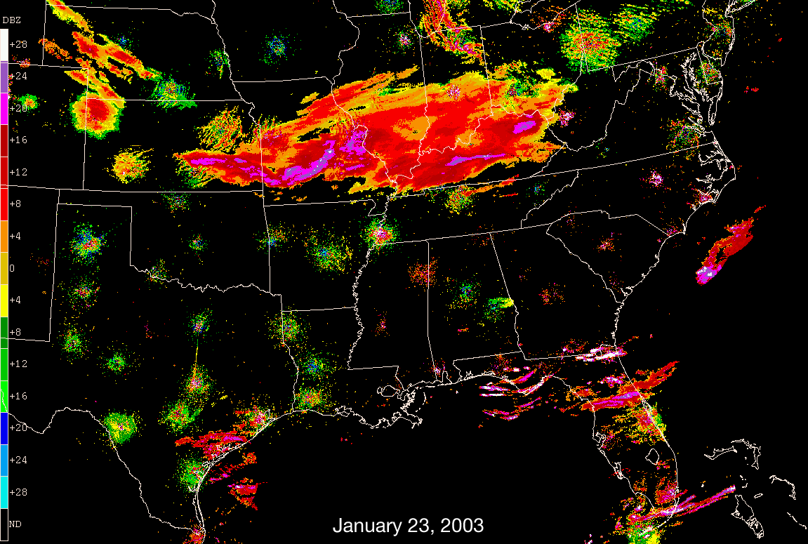
The hypothesis offered by Dutchsinse corresponds well with the information collected at this site - that the Nexrad weather radar systems have been secretly used as ultra-low frequency weather manipulation. When naturally or artificially stimulated, these resonant hotspots become visible to Doppler radar as atmospheric water vapor levels increase above the many fixed locations, and maintain themselves over time while high altitude cloud cover passes through. The rays and rings have occassionally been visible on Doppler radar, as on the night of January 23, 2003 (animated below).
What is being experienced by residents in throughout these US hotspots is also becoming very noticable in other areas of the world. The present scientific understanding of this unusual situation can be informed by understanding the relationship between these places where residents report intermittent rumbling, quaking and booming.
The mathematical relationship underlying the distribution of ultra-low frequency standing waves is defined by the quadratic iterated function [ zn+1 = zn2 modulus n ] (after P. Bourke), as expressed from the apex of the Great Pyramid of Giza, Egypt. By their precise sizes, axis-symmetric shapes, and aligned geopositions, the global system of ancient pyramids ambiently transduces and focusses the energy of solar flares and all other incoming cosmic radiations.
Earth booms and humming also recur often in Llanidloes, Mawnan, Hull, Saffron Walden, Bridlington, Goa, Klai, Auckland, Sydney, White Rock, Ranchlands, Ontario, and in the US in Newport, Anderson, Kimberley, Menomonee Falls, Pelham, Richmond, Wilmington, Nashville, Knoxville, Mobile, northern Florida, Knob Noster, Denver, Seattle, Novato, Arroyo Grande and Atwater.
The cases have become so severe that spontaneous combustion of objects by piezoelectric induction has been recurring in spates - in areas such as Tenerife, Babura, Lalapansi, Mapuve, Bodibe, Landovica, Longford, Glasgow, Messina, Peschici, Berici, across northern Greece, Ratria, Kakori, Mumbai, Kishtwar, Rangrik, Kota Baru, Santo Tomas, Georgetown, La Pampa, Melipilla, and in the US in Bellvue, Soudan SP, Minneapolis, Colorado Springs, Pueblo, San Mateo, Vallejo, San Francisco, Santa Barbara, Brentwood and New York City.